TUESDAY ……..November 2nd, 2021….. Time:….5:40 am EDT
.
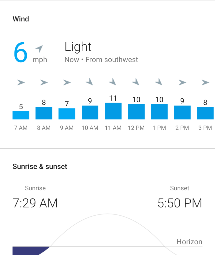
Feels like 41°F (High 54)…. CLOUDY …..Humidity 89 % …….
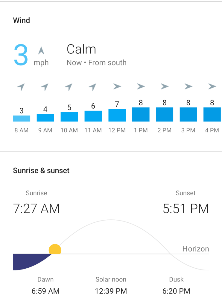
Wind 0 mph SSW rising to 8 mph at 2:00 pm …… Precipitation : 5 %
@ 5:00 pm……Water temperature 52.6 °F (11.3 °C); …………………..
Water plus air temperature = 93.6°F
Lat Long: 41.92 N ..73.96 W
.
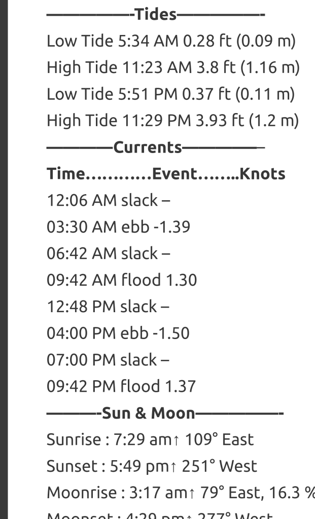
—————-Tides—————-
Low Tide 6:18 AM 0.01 ft (0.0 m)
High Tide 12:08 PM 4.2 ft (1.28 m)
Low Tide 6:41 PM 0.03 ft (0.01 m)
————Currents—————
Time…………Event……..Knots
01:00 AM slack –
04:06 AM ebb -1.53
07:24 AM slack –
10:24 AM flood 1.51
01:30 PM slack –
04:36 PM ebb -1.71
07:48 PM slack –
10:30 PM flood 1.54
———-Sun & Moon—————-
Sunrise : 7:30 am↑ 109° East
Sunset : 5:48 pm↑ 250° West
Moonrise : 4:30 am↑ 88° East, 8.7 % Waning Crescent
Moonset : 4:54 pm↑ 268° West
Daylight Hours: 10 hours, 18 minutes (-2m 28s)
[Ebb current is when the water flows towards the south (Poughkeepsie). Flood current is when the tide flows towards the north (Albany). Slack is the period in between when the water is still (not flowing north or south).]
Understanding USCG markers in our area: https://www.youtube.com/watch?v=oP8vNMQctjM&t=157s
.
NOTE: For updates throughout the day, use the links below. Also there are interesting links to videos about “our reach”.. ENJOY!
.
theRondoutRower.com
======================================================================
Kingston Weather: https://weather.com/weather/today/l/261a6340f82e978bc855b4f078e56ada8064b7df9db6b61ef062f63e9d515dcb
Tides:
https://www.tide-forecast.com/locations/Kingston-Hudson-River-New-York/tides/latest
Water Temperature
https://waterdata.usgs.gov/ny/nwis/uv/?site_no=01359139&blurb=%20USGS+Real-Time+Water+Data+Information
Currents:
https://tidesandcurrents.noaa.gov/noaacurrents/Predictions?id=HUR0509_9
Moon Phases, Sunrise/Sunset
https://www.timeanddate.com/astronomy/@z-us-12401
https://www.timeanddate.com/astronomy/night/
=====================================================================
Waterways, Rowing and Regattas: rowing through the ages https://www.youtube.com/watch?v=lSK-R8LzHc0
My Reach https://www.youtube.com/watch?v=2NyQrFYuYKY&t=193s
How to read a compass: https://www.nationaltrust.org.uk/features/how-to-read-a-compass#:~:text=The%20most%20important%20part%20on,in%20the%20direction%20of%20south.
===============================================
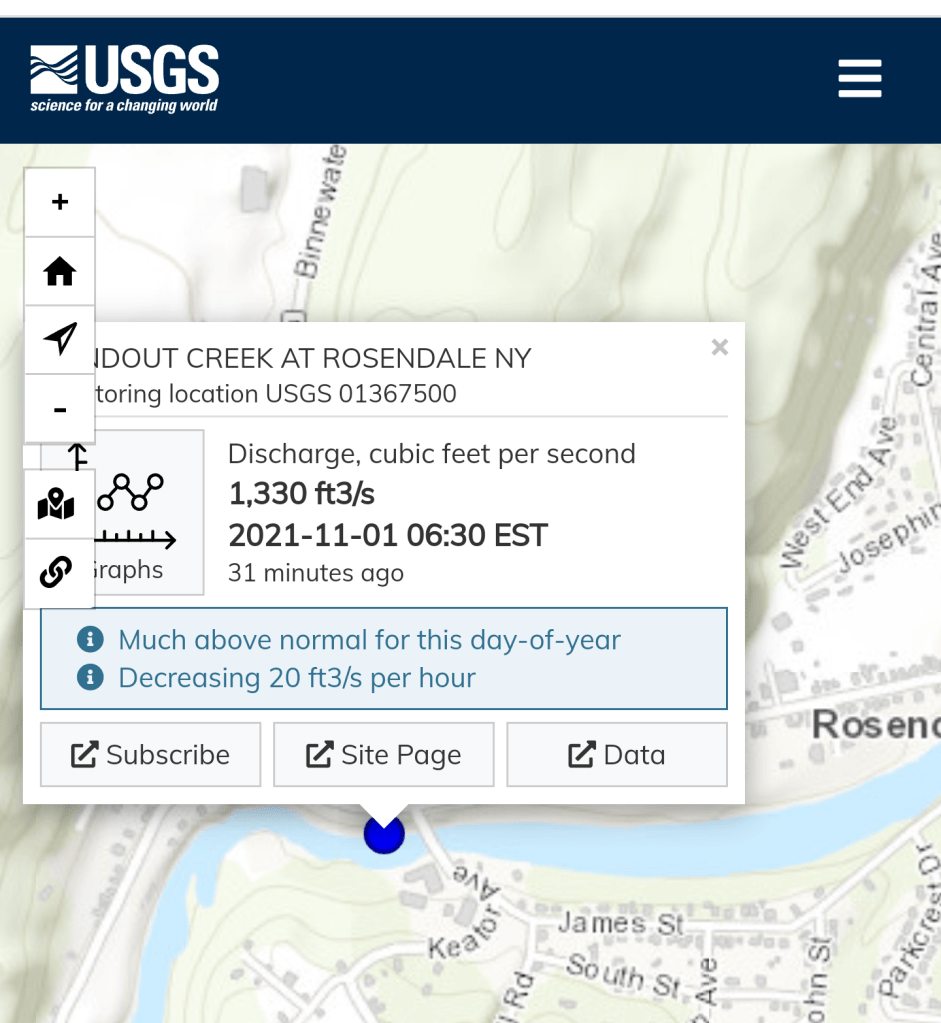
Waterflow at Rosendale
Click on this
https://dashboard.waterdata.usgs.gov/app/nwd/?region=lower48&aoi=default
Click on Bottom right “Detailed map symbology……”
Click on “+” to zoom into dot over Rosendale, NY
===========================================================